Monteveglio Cycle Path
Information
The Monteveglio Cycle Path is a pleasant loop itinerary of about 27 kilometers nestled in the hills of Valsamoggia, just outside Bologna (also part of the regional Ciclovie dei Parchi network). It is an accessible and smooth route, running entirely on low-traffic secondary paved roads and cycle paths. The true heart of the excursion is the Abbey of Santa Maria di Monteveglio, a Romanesque gem set at the top of a medieval hamlet and surrounded by badlands, broadleaf woods, and traditional crops. Thanks to the start and finish lines close to the Bazzano railway station, the itinerary is perfect for a day trip in train+bike mode.
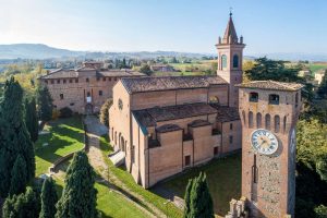
The route starts from the Bazzano railway station. Before heading out into nature, the town’s historic center is worth a stop, featuring the majestic Fortress of Bazzano and its Civic Museum filled with archaeological finds. After leaving the center, you take secondary roads and cycle paths until reaching the boundaries of the Monteveglio Abbey Regional Park. Skirting the town of Monteveglio, you face a short but intense climb on a paved road to reach Monteveglio Alto and its spectacular Romanesque Abbey of Santa Maria. Characterized by its red brick structure and framed by cypresses, the abbey preserves its original architecture and is located at the end of a quiet and picturesque medieval hamlet. Going down Via Abbazia, you reach the Park Visitor Center in the meadows of San Teodoro. The tour continues south parallel to the Ghiaia di Serravalle stream, immersing itself in a relaxing countryside setting among broadleaf woods (oaks, hornbeams, and maples), badlands, and small farms cultivated with cherry and walnut trees. The climb ends at an altitude of around 300 meters, on the ridge that divides the Rio Paraviere valley from that of Rio Marzatore. Upon reaching the locality of Tagliolina, you begin to descend along the shady valley floor of Rio Marzatore. The itinerary closes the loop about two kilometers from Bazzano, allowing you to comfortably catch the train back.


bar_chart Technical Info
- Km: Approximately 27 km (including the detour via Monteveglio Alto)
Elevation gain: +380 m uphill / -380 m downhill
Difficulty: Leisure/Hiking (easy hilly route)
Surface: Tarmac, secondary roads, cycle paths and local roads with little traffic. Gravel bikes, e-bikes or road bikes are recommended
download Download
Technical clothing for cycling
Map
First aid kit
GPS system for orientation
Telephone and battery charger + power bank
The cycle route can be travelled all year round.
Download the GPX track.